A brief history of the French road network
Birth of a national network
The Middle Ages were clearly a period of a primitive road network, but things would be about to change with the Renaissance period. Urban and commerical growth contributed to a boom in travel, both nationally and internationally, so transit routes needed to improve as well.
It would not be until the early 1500s that attention would be given to the state of the nation's roads. The main radial axes between Paris and the other major cities, known as the Routes Grandes, were those that saw the greatest attention. Their importance meant that they were wide - although their width varied by region, from 24 to 64 feet wide, and generally free from obstruction. Other roads of the time were still nothing more than a cart track, often unkempt and overgrown.
However, the increasing usage of draft horses and heavier carts meant that roads needed to be more durable as rutting was a big problem. This had one benefit, in that it allowed paving stones to be transported futher and faster. This improved availability of horses, so more roads could benefit from paving.
Roads in towns were generally paved first, but this spread to the Grandes Routes by decree of the monarch. Such roads would be upgraded to a width of 16 metres, with the middle 5 metres paved. If anything was in the way, it was to be removed or demolished in the "general interest of the State" - even if it was someone's house. Even materials could be taken from neighbouring land and buildings if they were required in the construction of the road, with no compensation ever forthcoming.
Passage along the Grandes Routes was usually by way of toll payment, even if travellers avoided the road by taking to the fields alongside them. Local towns had to pay for the upkeep of roads within their bounds, with additional levies charged to pay for the construction of important bridges.
But under whose responsibility did this fall?
Fast forward to 1599, and it was only now that some form of centralisation would become evident. Many years of war and civil conflict led to roads beginning to crumble once again. King Louis XIV would create the post of Grand Voyer - Chief Surveyor - to take charge of all suveyors within France, and would also collate a document outlining the general state of roads in the country.
Lieutenants were appointed to act on the Grand Voyer's behalf out in the regions, as well as to draw up cost estimates, approve any works to be carried out, and ensure nobody abused the system to their profit. Even the jurisdiction of roads would become the responsibility of the Grand Voyer, albeit from 1607.
Over the following decades, responsibility wavered. The post of Grand Voyer was abolished in 1627, only to come back in 1645, then disappear again in 1665. Responsibility would be shared amongst various financial comptrollers and treasurers, a benefit of which would be vast increases in the roads and bridges budget - albeit broken by further war in 1675. Post war budgets would not return to the same levels, with local councils having to make up the shortfall, even for the Grandes Routes running through their areas.
The first road classifications
By the turn of the 18th Century, progress in road improvement was painfully slow. Many roads were still in a poor state, despite improvements made by state officials, and there was a clear divide in network coverage between the north and south. Things were not helped by the lack of willingness by the monarch, Louis XIV, to cover the full costs of improvements. The consequence was that only the Grandes Routes and major bridges were funded by the State.
Under the reign of Louis XV, budgets would increase from 1m livres tournois to a whopping 9.4m livres tournois (around £48 million in today's money). Standards improved following the creation of the Conseil général des ponts et chaussées (General Council of Bridges and Roads), who would be resposnible for all legislation concerning technical standards . A technical school was also established to ensure all engineers and surveyors were qualified to the same level.
One allowance that was made within the new rules was concerning landtake. As roads still had to be built as straight as possible, the issue of landtake was still a sore subject. However, if land was to be acquired by the State, then landowners could now recover the land that was occupied by disused alignments, with the excess covered by financial reimbursement (albeit very delayed). Careful consideration was also given to alignments and gradients taken by roads in mountainous regions.
Further to this, a strict heirarchy of all interurban roads was created for the first time. Classification was determined according to location, size and importance of towns served, and the presence of a postal or courier service, as well as stating the required width of said road. This went as far as implememting minimum road widths for each category of road:
| Category | Description | Width | Approximate number |
| Grand Route | roads linking Paris with ports or frontier posts | 60 feet | 62 routes |
| Route | roads linking Paris with provincial capitals | 60 feet | 145 routes |
| Grand Chemin | postal route linking Paris or provincial capitals to other cities | 48 feet | 28 routes |
| Chemin | postal route between cities | 36 feet | 218 routes |
| Chemin de traverse | other routes between cities | 30 feet |
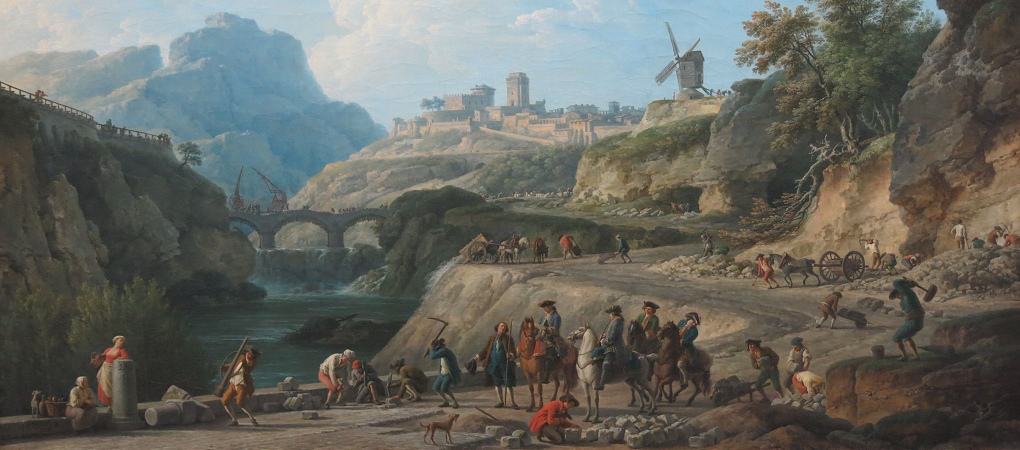
Extract from
The Construction of a
Main Road
by Joseph Vernet, 1774
This classification was refined in 1776, when the five categories was replaced by a heiarchy of four road classes. In addtion, the mandated width of roads was narrowed in order to reduce maintenance costs as well as inconvenience to landowners. Roads were permitted to be narrower where terrain was difficult or costs would otherwise be prohibitive.
| Category | Description | Width |
| I Routes Royales |
cross-country routes linking Paris with the provincial capitals, ports and centres of commerce | 42 to 60 feet |
| II | roads linking the provincial capitals with each other, and Paris with other cities | 36 feet |
| III | regional routes linking cities with each other | 30 feet |
| IV | municipal roads between small towns and villages | 24 feet |
| << Previous | Page 3 | Next >> |